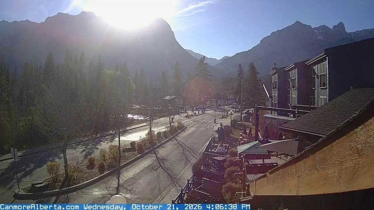
Mount Rundle in Canmore (Alberta) — online webcam
History of the name: from "house-mountain" to a missionary's legacy
Mount Rundle is one of the most recognizable symbols of the Canadian Rockies, and its history spans thousands of years. The first inhabitants of these lands — members of the Cree people — called the massif Waskahigan Watchi, which translates as "house-mountain". This name reflected the monumental shape of the mountain, which truly resembles a giant shelter or dwelling on the edge of the Bow Valley.
The modern name appeared much later. In 1858, explorer John Palliser renamed the mountain in honor of Reverend Robert Rundle — a Methodist missionary who worked with Indigenous peoples in the 1840s. Rundle was engaged in educational activities among the native peoples of the region, and Palliser decided to immortalize his name on the map of Western Canada. Interestingly, the reverend himself never conquered this peak — he simply preached in the foothills, and the mountain became a monument to his mission.
Geological wonder: the Rundle Thrust
Anyone looking at Mount Rundle from the plain or through a webcam in Canmore sees the result of colossal tectonic processes. The characteristic wedge-shaped shape of the mountain and neighboring massifs was formed by the Rundle Thrust — a geological fault that created a 50-kilometer ridge between Canmore and Banff. This is one of the most studied structures in the Rocky Mountains: ancient limestone rocks about 340 million years old were thrust over younger deposits as a result of tectonic plate collision.
The Rundle Thrust is a classic example of a thrust fault, when a massive rock plate moves tens of kilometers horizontally. Thanks to this process, rocks formed during the Devonian period reached the surface, when a shallow tropical ocean stretched across the site of modern Alberta. This is why fossils of ancient marine organisms — brachiopods, corals, and trilobites — are found on the slopes of Rundle.
Height and scale: numbers that boggle the mind
The height of Mount Rundle is 2,949 m above sea level, and the topographic prominence is about 1,240 m. This means that from the base to the summit, the elevation difference exceeds a kilometer — an impressive vertical relief that makes Rundle the dominant landform in the Bow Valley.
But Rundle is not a single peak, but an entire mountain massif. The mountain stretches 25 km from Canmore to Banff and consists of several peaks with a characteristic wedge-shaped form. Tourists and geographers distinguish Rundle 1, Rundle 2, Rundle 3, and so on — each "step" of this giant stone wedge represents a separate peak with its own relief and character.
Wildlife: nature at the foot of the mountain
Mount Rundle is located within Banff National Park — the oldest national park in Canada, established in 1885. This status ensures the protection of foothill ecosystems, and the wildlife here remains remarkably diverse.
The park is home to black bears, grizzlies, deer, elk, bighorn sheep, mountain goats, wolves, and coyotes. On the slopes of Rundle, you can encounter bighorn sheep grazing on alpine meadows above the treeline. Mountain goats prefer steeper rocky sections that are harder for predators to reach. In the lower part of the slopes and in the Bow Valley, elk and deer are common, and at dusk you can hear the howling of wolves — they hunt ungulates in packs in the foothills.
Hiking and scrambling: routes to the summit
For those who want to see Rundle not on a screen but in person, there are several proven routes. The most popular start from Canmore is the EEOR (East End of Rundle) trail, 5.8 km round trip with an elevation gain of about 1,738 m. This is a serious route that leads to the eastern peak of the massif and requires good physical fitness.
An alternative option is the main route to the central peak from Banff, about 11 km round trip with an elevation gain of about 1,577 m and a hiking time of 7-8 hours. This path starts at Bow Falls and the Banff Springs Golf Course, crosses a bridge over the Spray River, and then winds up the western slope in switchbacks.
The ascent of Rundle is classified as scrambling — it does not require climbing equipment but includes steep sections and rock slabs. The upper third of the route from Banff passes along an open slope with the use of hands for support. The best time for climbing is the period when the snow has completely melted on the western face, usually from July to September.
Panorama from the summit: what you can see on the horizon
Those who reach the summit are rewarded with one of the most impressive views in the Canadian Rockies. From the summit, there is a panoramic view of the towns of Banff and Canmore, the Bow River gorge, the Three Sisters (Big Sister, Middle Sister, Little Sister), Cascade Mountain, and Lake Minnewanka.
The Three Sisters — another landmark of Canmore — from the summit of Rundle are seen from a completely different angle than from the plain. Cascade Mountain, resembling a giant stadium, dominates the northwest, and in clear weather the outline of Lake Minnewanka can be guessed in the north — the very one on postcards and calendars with the inscription "Canada".
Canmore: a town between mountains
Canmore is not just a dot on the map at the foot of Rundle. It is a dynamic mountain town with a population of about 16,000 people, located in the Bow Valley at an altitude of 1,300 m above sea level. The town grew up around the coal industry in the late 19th century, but today it lives on tourism, services, and serving transit traffic between Calgary and Banff.
Canmore's main street — Main Street — runs parallel to the Trans-Canada Highway and is the center of urban life. This is where restaurants, shops, galleries, and hotels are concentrated. The town is surrounded by mountains on all sides: Rundle dominates to the south, the Three Sisters to the west, and the Spray Mountains range closes the horizon to the east.
What the camera shows
The online camera with a view of Mount Rundle is installed within Canmore and broadcasts a city intersection with road traffic, traffic lights, and cars. In the background of the frame rises a mountain range with high peaks surrounded by coniferous forest — this is the Rundle massif in all its grandeur.
In the middle part of the frame are commercial buildings with characteristic roofs and a modern public building. The street infrastructure is clearly visible: roads, intersections, sidewalks, and a bike lane. Pedestrians move along the sidewalks — locals and tourists who stroll through Canmore at any time of year.
The camera operates in real time and allows you to observe the road situation in the town, see weather conditions — whether it's freshly fallen snow on the slopes of Rundle or a clear sky over the Bow Valley. It's a convenient way to assess the situation on the ground, plan a trip, or simply enjoy the view of the Canadian Rockies without leaving home.
Similar cameras
Find similar