

City of Asha in Chelyabinsk Oblast — online webcam
Asha — a city in the mountain valley of the Southern Urals
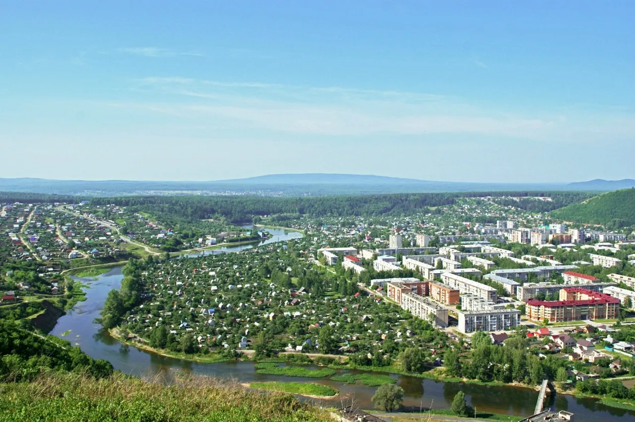
Asha is located in the west of Chelyabinsk Oblast, where the Sim River breaks through the mountain ranges of the Southern Urals. This is one of those Ural cities that is literally woven into the landscape — industrial development coexists here with wild nature, and apartment buildings are framed by rocky slopes and coniferous forests. The online webcam allows you to see this unique panorama in real time: the winding riverbed, neighborhoods with panel and brick houses, the green private sector, and the mountain relief on the horizon.
History — from a railway station to a metallurgical center
The city originated in 1898 as a settlement during the construction of the Samara-Zlatoust railway. Construction of the main line began in 1895 at the expense of the state treasury, and a settlement quickly grew around the station. The name was inherited from the Asha River — a tributary of the Sim, although the city itself stands on the banks of the Sim. Asha received city status in 1933, and since then has remained the largest industrial center in the west of the region.
Interestingly, Asha is the westernmost of the large cities in Chelyabinsk Oblast, located near the border with Bashkortostan. This leaves an imprint on the local flavor: Ural and Bashkir traditions mix here, and the landscape resembles a mountain country rather than the steppe Trans-Urals.
Sim River — the artery of the city
The Sim is a tributary of the Belaya (Kama basin), flowing through the entire Chelyabinsk Oblast and Bashkortostan. Within the city limits of Asha, the river forms characteristic rocky slopes along the banks, which are clearly visible from an elevated position. In the 18th–19th centuries, barges with iron from the Minyarsky plant were sent down the Sim, and until 1969, timber rafting was carried out along the river and its tributaries. Near the mouth there was once a boom where timber was collected, floated down from the upper reaches in spring.
Today, tourist rafting trips are organized on the Sim, and the view of the winding riverbed from the camera gives an idea of how the river divides the city into parts, connecting the districts with bridges.
Asha Metallurgical Plant — the heart of the city
The city-forming enterprise — the Asha Metallurgical Plant — is one of the largest producers of metal products in the Southern Urals. The plant's history is literally woven into the mountain valley: this is a rare example of a place where industrial architecture organically coexists with the mountain landscape. The enterprise shaped the city's appearance — residential neighborhoods for workers were built here, infrastructure was formed, and roads were laid.
In the panorama from the webcam, the plant's territories do not dominate the frame, but it is they that created the urban environment we see: apartment buildings, roads, a bridge over the river.
Attractions in the center of Asha
The city center is rich in monuments and places for walks. In the Park of Culture and Recreation named after P.A. Pilyutov, a monument to internationalist warriors was erected. In the central part is the Monument of Glory — a tribute to the warriors who fell during the Great Patriotic War. Nearby is the Monument to the Liberator Warrior and well-maintained squares with fountains.
On Tolstoy Street, there is a museum and exhibition center with a local history exhibition dedicated to the history of metallurgy in the region. The Palace of Culture is an architectural landmark of the center, where city events and holidays are held.
Mountain landscape and tourism in the surroundings
The Asha district is often called "Ural, similar to Switzerland" — and from the webcam you can clearly see why. The city is surrounded on all sides by mountain ranges of the Southern Urals; forests and hilly relief stretch in the background of the panorama. Near the city rises the Karatau Range, and dozens of tourist routes have been laid in the surrounding mountains.
Karst caves are hidden in the mountains, and on the Sim River there is an unusual natural attraction — the "Hole Rock". This is one of the most famous tourist areas of the Southern Urals: in summer, rafting trips are organized on the river, and in winter, ski slopes operate.
Climate and nature of the Asha district
Asha is located in a zone of moderately continental climate with pronounced mountain character. Winters here are cold and snowy, summers are warm but short. The forests surrounding the city are mixed: coniferous species alternate with birches and aspens, creating the green palette visible from the camera. In the private sector — individual houses with garden plots, densely overgrown with vegetation.
The mountain relief also affects weather conditions: in the Sim River valley, fog often forms, and on the slopes of the ranges the wind is felt stronger than in the center. The webcam in real time allows you to observe how the lighting changes throughout the day — sunrise over the mountains and sunset behind the range create a unique light picture.
Transport and communications
Asha is an important transport hub in the west of Chelyabinsk Oblast. A regional highway connecting Chelyabinsk with Bashkortostan passes through the city. The Asha railway station on the Samara-Zlatoust line is still operational — it was from it that the city began. In the panorama from the webcam, roads and a bridge over the Sim River are visible, along which there is constant traffic.
The city is connected by bus service with neighboring districts — Minyar, Satka, Mezhevye. From Chelyabinsk, you can get here by car via the M-5 highway with a subsequent exit onto the regional road.
What you can see on the camera
The webcam is installed on an elevated position and provides a panoramic view of the center of Asha. In the foreground is the Sim River with its winding bed, flowing through the city. In the central part of the frame are multi-story residential neighborhoods: panel and brick houses, some with red roofs. Around the development, the private sector with individual houses and dense green vegetation is visible. In the background, forests and hilly relief of the Southern Urals mountain range stretch. Roads and a bridge over the river are visible. The online camera operates in real time, allowing you to observe the life of the city at any time of day.


