

Uyuga Holiday Camp in Kurma — online webcam
Cape Uyuga — the rocky guardian of Maloye More
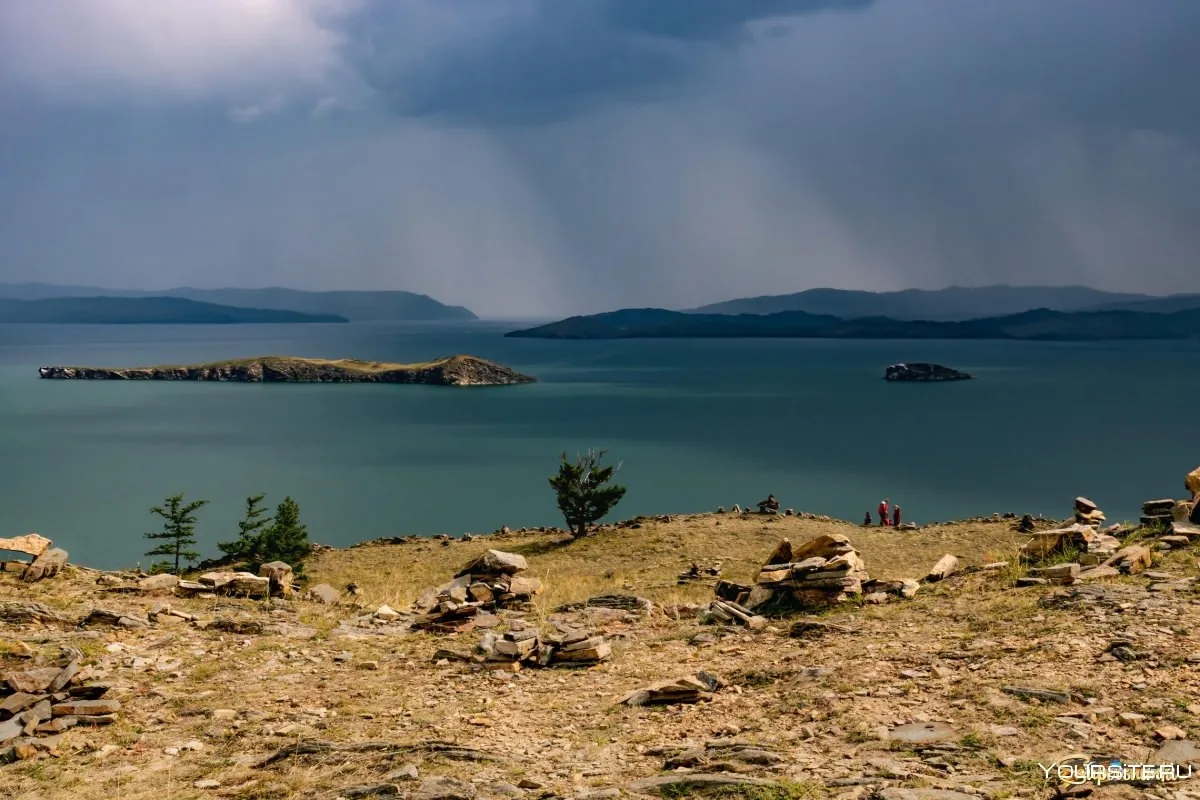
On the western coast of Baikal, in the very heart of the Maloye More Strait, a narrow rocky peninsula juts into the waters — Cape Uyuga. This place connects the mainland shore with a rocky ledge about 16 meters above the lake level, forming a picturesque panorama that can be observed via the online webcam from the "Uyuga" holiday camp. The isthmus is composed of gravel deposits and exposed rock formations, overgrown with sparse coniferous trees. From the eastern side, the cape offers a view of the vast expanse of Kurma Bay — one of the warmest and most visited areas of Maloye More.
Kurma is a small village in the Olonkhonsky District of Irkutsk Oblast, located on the western shore of Olkhon Island. The name "Kurma" has Buryat origins and is connected to local toponymy. The village is known to tourists as one of the key points for exploring Maloye More — the strait between the western shore of Olkhon and the mainland coast of Baikal. It is here, at Cape Uyuga, that the online camera is installed, broadcasting the bay panorama in real time.
Maloye More Strait and Kurma Bay
Maloye More is one of the largest straits of Baikal, separating Olkhon Island from the mainland coast. Its length is about 70 kilometers, and its width varies from 5 to 20 kilometers. Kurma Bay, on whose shore the "Uyuga" holiday camp stands, cuts into the land on the eastern side of the strait. The water in the bay warms up significantly better than in open Baikal — in summer the temperature can reach +22°C, making this place attractive for swimming and water excursions.
The waters of Maloye More feature a complex underwater terrain — there are numerous underwater ridges, shoals, and deep depressions. The depth of the bay near Cape Uyuga reaches several tens of meters, and the bottom is predominantly rocky. Several islands are located in the bay's waters, the largest of which — Oltrek Island — is visible from the holiday camp. Oltrek is a small rocky island covered with sparse vegetation, a popular spot for boat excursions.
The eastern shore of Kurma Bay is formed by the Primorsky Range — a mountain chain stretching along the western coast of Baikal. The range reaches heights of up to 1000–1500 meters and forms a majestic backdrop for the panorama opening from Cape Uyuga to the east. The slopes of the range are covered with larch taiga, which turns golden-yellow in autumn, creating a contrast with the blue of Baikal's waters.
"Uyuga" Holiday Camp — infrastructure and accommodation
The "Uyuga" holiday camp is a 2* country park-hotel located on the cape. The facility specializes in family, corporate, and individual recreation. According to aggregator data, the camp consistently receives high ratings — 4.9 out of 5 based on several hundred reviews.
Guest accommodation is organized in separate wooden cabins and buildings. The rooms are compact but equipped with everything needed for comfortable living. There is a cafe on the territory, sports facilities, and an equipped beach. The camp is located near the cape of the same name, providing guests with direct access to the waterfront and panoramic viewing platforms.
Accommodation costs start from approximately 9,000 rubles per day, depending on the season and room category. Booking is available through major tourist platforms. The camp is suitable for family vacations with children — the calm atmosphere, clean water in the bay, and the absence of large tourist crowds make this place attractive for family recreation.
Seasonal features: summer and winter on Maloye More
The summer season on Maloye More is the time for pleasure boats, kayaking, and snorkeling. The water in Kurma Bay warms up to comfortable temperatures, allowing swimming even on cool days. Boat excursions to Oltrek Island and other attractions of the bay depart from the "Uyuga" holiday camp. In summer, yellow poppies bloom on the slopes of the cape — rare plants listed in the Red Book, which grow on the long rocky spit connecting the cape to the mainland.
In winter, Kurma Bay transforms. From January, the waters are covered with ice up to 30 centimeters thick. Baikal ice is famous for its transparency — the rocky bottom can be seen through it at a depth of several meters. This time is popular for ice skating, outdoor hockey, and ice walks. In April, the bay hosts ice sailing competitions — windsurfing on ice, which attracts athletes from across Siberia.
The webcam with an eastward view allows you to observe seasonal changes in real time — from summer greenery and blue waters to winter ice expanses and snow-covered slopes of the Primorsky Range.
Attractions around Kurma
Kurma is a starting point for exploring several natural attractions on the western coast of Baikal. Within walking distance from the "Uyuga" holiday camp is Tsagan-Khushun Cape — a rocky cape with panoramic views of Maloye More. A bit further is Khada Cape — another spot with impressive views of the strait.
To the south of Kurma lies the Sarma Gorge — the birthplace of the famous Sarma wind — the strongest and most dangerous wind on Baikal, whose speed can exceed 40 meters per second. Mukhor Bay is another picturesque spot of Maloye More, located south of Kurma Bay, known for its sandy beaches and tranquil atmosphere.
In the village of Kurma itself and its surroundings, there are other tourist bases — "Baikal Fairy Tale," "Danko," "Oltrek." However, it is the "Uyuga" camp that occupies the most advantageous position on the cape, providing a panoramic view in all directions.
Flora and fauna of Cape Uyuga
The vegetation of Cape Uyuga is typical of the dry rocky slopes of Baikal's western coast. Larch and pine trees predominate here, adapted to strong winds and poor soils. On the gravel spit connecting the cape to the mainland, endemic species grow, including yellow poppies, which bloom in July-August and attract photographers and naturalists.
The animal world is represented by typical inhabitants of the Baikal taiga — here you can encounter chipmunks, squirrels, and occasionally foxes and musk deer. The bay's waters are home to Baikal omul, whitefish, pike, and perch. Gulls and mergansers nest on the rocky shores, and in the summer months, eagles hunting fish can be seen above the water.
The ecosystem of Maloye More is sensitive to anthropogenic impact, so nature protection restrictions are in place on the cape and adjacent waters. Tourists are advised to keep clean and not leave trash on the shore.
Climate and weather conditions
The climate of Baikal's western coast is sharply continental with the influence of the lake's enormous water mass. Winters here are milder than in mainland Irkutsk Oblast, thanks to the thermal influence of Baikal. Summers are cool, but in Maloye More the water warms up significantly better than in the open lake.
The average January temperature in the Kurma area is about -18°C, July — +16°C. However, due to the strong winds characteristic of the Baikal region, the perceived temperature can be significantly lower. The Sarma wind, blowing from the gorge of the same name, is capable of creating waves up to 4–5 meters high in the Maloye More Strait.
The webcam with an eastward view allows you to assess current weather conditions — cloud cover, visibility, and the state of the water surface. This is especially useful for tourists planning a trip to Baikal and for those who enjoy observing natural phenomena in real time.
History and significance of the place
Cape Uyuga and the surroundings of Kurma have a long history of settlement. These lands were traditionally inhabited by Buryat tribes engaged in cattle breeding and fishing. The name "Uyuga" translates from Buryat as "breast" or "hill" — which accurately describes the shape of the peninsula jutting into the bay's waters.
In Soviet times, a holiday camp was organized on the cape, which has been operating continuously since then, having undergone several stages of reconstruction and modernization. Today it is a modern recreational center that preserves the atmosphere of Baikal hospitality and offers guests the opportunity to experience wild nature in comfortable conditions.
Maloye More has always played an important role in the life of the local population — as a transport artery (winter roads run across the ice in winter), as a fishing area, and as a place of recreation. Today, the strait is one of the most visited tourist areas of Baikal, attracting travelers from all over Russia and abroad.
What the camera shows
The webcam from the "Uyuga" holiday camp with an eastward view broadcasts the panorama of Kurma Bay — part of the Maloye More Strait on Baikal. In the foreground is the rocky hilly section of Cape Uyuga with sparse coniferous trees and characteristic stone deposits. Oltrek Island is visible in the bay's waters — a small rocky island, a popular spot for boat excursions.
In the background are the mountainous shores of the opposite coast, formed by the spurs of the Primorsky Range. The slopes are covered with larch taiga, which changes color depending on the season — from bright green in summer to golden in autumn and snow-white in winter. A watermark is present in the lower right corner of the image.
The online camera allows you to observe the state of the waters in real time — in summer you can watch passing boats and yachts, in winter — the formation of ice cover and its transparency. In good weather, the camera shows a detailed panorama of the bay for several kilometers, including tourist bases and piers on the opposite shore. This is a great opportunity to assess the situation before a trip to Baikal or simply to enjoy the beauty of Maloye More without leaving home.


