

🏙️ Webcams Val-d'Aigoual online — watch in real time
1 cameras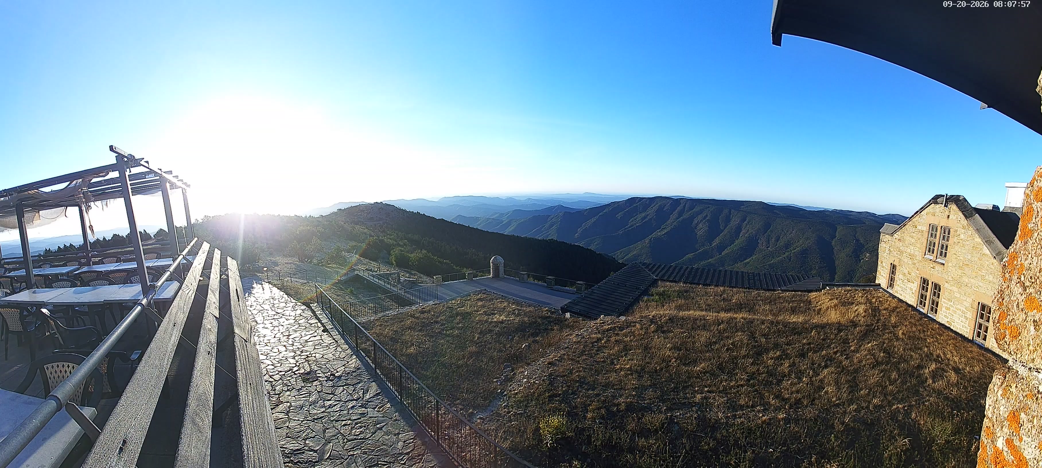
Val-d'Aigoual — the pearl of the Cévennes
Val-d'Aigoual is a young commune in southern France that appeared on the country's map on January 1, 2019 following the merger of three historic settlements: Valleraugue, Notre-Dame-de-la-Rouvière, and part of Meyrueis. This territory is located in the Gard department, Occitanie region, and occupies a picturesque valley at the foot of one of the most remarkable mountains of the Massif Central. Val-d'Aigoual attracts travelers with an unusual combination of mountain terrain, rich history, and unique climatic conditions that make it a destination for meteorologists, naturalists, and outdoor enthusiasts.
The valley is surrounded by forested slopes, with dozens of hiking trails of varying difficulty. For centuries, locals have been engaged in sericulture and farming, adapting to the harsh weather conditions of the highlands. Today, Val-d'Aigoual is also an open-air natural laboratory where climate change is studied and the biodiversity of the Cévennes is preserved.
Origin of the name
The toponym "Aigoual" has deep roots in the past. It was first recorded in historical documents from the 13th century: in 1228, "ad stratam Aigoaldi" is mentioned — a road in these parts; in 1238, "marca Algoaldi" as a territorial boundary; and in 1249, "mons Aigoaldi" — the mountain itself. In Occitan, the summit is called "Augal," and linguists link the etymology to the Latin root "aqua" — water. This is no coincidence: Mont Aigoual receives record rainfall among all points in France, in places up to 2000 millimeters per year. The pre-Indo-European or Celtic element in the name also points to water, stream, or wet place — a definition that accurately describes this mountain, covered in fog and rain for most of the year.
The historic capital of the valley is Valleraugue, which in Occitan sounds like "Valarauga." The name combines two words: "val" — valley and "Augal" — the mountain itself. The settlement is located at the confluence of the Clarou and Hérault rivers, near the gateway to the Cévennes, and is considered one of the communes of the Massif Central with the greatest elevation difference between its highest and lowest points — nearly 1300 meters.
Meteorological observatory at the summit
The heart of Val-d'Aigoual is the Mont Aigoual meteorological observatory, rising 1567 meters above sea level. It is the highest point of the Cévennes massif and simultaneously the highest point of the Gard department. The observatory was built in 1893 and has been continuously supplying weather and climate data ever since. It is unique in that it remains the last inhabited weather station in France — meteorologists live and work here year-round, despite the harsh conditions.
In winter, temperatures drop to -30°C, and winds reach hurricane force. So much precipitation falls that over a year it could cover a two-meter layer. The observatory hosts a free exhibition about the meteorologist profession and methods of atmospheric observation. Visitors can learn how weather forecasts are formed and why Mont Aigoual became a key point for studying the climate of southern France.
From the observatory's viewing platform, a breathtaking panorama opens up: in clear weather, the green valleys of the Cévennes are visible, and on the horizon — the shores of the Mediterranean Sea and the snow-capped peaks of the Alps. It is this view that the Val-d'Aigoual webcams capture, allowing you to feel the scale and beauty of these places without leaving home.
The Hérault River originates here
One of the most important rivers of southern France — the Hérault — originates on the slopes of Mont Aigoual. Its source is located in the Cévennes massif, and from here the river begins its journey through the Gard and Hérault departments, the latter of which it gave its name to. Val-d'Aigoual can be called the cradle of an entire river system that nourishes fields and cities for hundreds of kilometers downstream.
The village of Valleraugue, the historic capital of the valley, stands at the confluence of two rivers — the Clarou and the Hérault. This place is called the "gateway to the Cévennes," as it is here that a deep gorge begins, leading into the mountains. The waters of the Hérault are clear and cold, and their level depends heavily on the season and the amount of rainfall on Mont Aigoual. The river valley creates a unique microclimate favorable for vegetation and agriculture.
Nature and vegetation of the Aigoual massif
The Mont Aigoual massif is part of the Cévennes National Park — the only national park in France managed jointly with local residents. The nature here is striking in its contrasts: once, in the 18th century, the slopes were covered with dense forests and pastures, but overgrazing and deforestation destroyed the vegetation cover. In the 20th century, large-scale reforestation work began, resulting in the Lapassetrie arboretum — a unique collection of trees from around the world.
Today, the arboretum is home to more than 70 species of coniferous and deciduous trees: Atlas cedars, sequoias, spruces, firs, and many exotic species acclimatized to highland conditions. Reforestation programs have turned bare slopes into a green carpet that protects the soil from erosion and creates habitat for rare animals and birds.
The climate of the massif is extreme: high humidity, frequent fogs, heavy snowfall in winter, and cool summer create conditions more reminiscent of northern latitudes than southern France. This is why the vegetation here is unique — you can find species characteristic of completely different ecological zones.
The 4000 Steps Trail — the path to the summit
One of the most impressive hiking trails in the region is the "Montée des 4000 marches", or "Climb of 4000 Steps." This is an 11-kilometer trail with an elevation gain of 1222 meters, leading from Valleraugue to the summit of Mont Aigoual. The path passes through rock steps ranging from 20 to 70 centimeters in height, carved into the stone many years ago for the needs of the observatory and forestry.
The climb requires good physical fitness but rewards the traveler with changing landscapes: from shady beech forests to alpine meadows and bare rock outcrops. At the summit, tourists are greeted by the observatory and a panoramic platform offering views of all the surroundings of Val-d'Aigoual. Many tourists prefer to observe the mountains through Val-d'Aigoual webcams before deciding on a real ascent.
Winter recreation on Mont Aigoual
When snow falls, Val-d'Aigoual turns into a winter fairy tale. On the slopes of Mont Aigoual operates the Prat Peyrot ski resort, offering 14 alpine ski runs of varying difficulty. This place is suitable for both beginners and experienced skiers — elevation differences and varied terrain create conditions for skiing at your own pace.
In addition to downhill runs, the resort offers 60 kilometers of cross-country ski trails along scenic forest paths. Nordic sports enthusiasts appreciate Prat Peyrot for its authentic atmosphere and the absence of crowds typical of large alpine resorts. Val-d'Aigoual webcams in winter show snowy slopes and lift operations, helping to choose the best day for skiing.
Three peaks and legends of the Cévennes
Mont Aigoual is not one peak but three, each with its own character. Pic Ferrège, Signal de l'Hort de Dieu ("Signal of the Garden of God"), and the third, unnamed peak form a distinctive silhouette visible for many kilometers. The name of the second peak is linked to a legend about a garden planted by God — according to tradition, it is here that heaven meets earth.
The Cévennes are rich in myths and legends passed down from generation to generation. Locals tell of mountain spirits, mysterious fires on the peaks, and healing springs hidden in the forest thicket. These stories give Val-d'Aigoual a special charm that attracts not only tourists but also folklore researchers.
The silk history of the valley
In the Middle Ages and modern era, Val-d'Aigoual and surrounding settlements of the Cévennes lived by sericulture — the breeding of silkworms. The region's climate allowed the cultivation of white mulberry, whose leaves serve as the sole food for silkworm caterpillars. The silk industry came from Byzantium around 550 AD and gradually spread to the southern regions of France where climatic conditions permitted.
The peak of the silk industry in the neighboring Ardèche department led to the emergence of more than 400 silk-spinning mills. Val-d'Aigoual, as part of the Cévennes, also participated in this trade: peasants raised silkworms in their homes and then sold cocoons to special manufactories. Today, traces of this industry can be found in old buildings and museums of the region, and the tradition of growing mulberry trees has been preserved in local gardens.
Climate and weather records
Mont Aigoual holds several meteorological records in France. Annual precipitation in places reaches 2000 millimeters, making it one of the wettest places in the country. Fog envelops the summit more than 200 days a year, and wind regularly exceeds 150 km/h. In winter, temperatures drop to -30°C, creating conditions comparable to mountain regions at much higher altitudes.
These extreme conditions attracted the attention of meteorologists in the late 19th century. The observatory became a key station for studying atmospheric processes and forecasting weather in southern Europe. Today, data from Mont Aigoual is used to model climate change and predict extreme events — from floods to droughts.
What the cameras show
Val-d'Aigoual webcams are installed at key points in the valley and on the approaches to the summit of Mont Aigoual. They broadcast views of the meteorological observatory, mountain landscapes, the village of Valleraugue, and surrounding slopes. In real time, you can observe the changing weather — from sunny sunrises to foggy days when clouds drift through the valley.
Cameras at the summit of Mont Aigoual show panoramas of the Cévennes, and in clear weather — the Mediterranean Sea and the Alps. Broadcasts from Val-d'Aigoual help tourists plan trips, skiers assess trail conditions, and nature lovers enjoy the beauty of this unique corner of France without leaving home.