Intersection on the A108 Highway near Manila Village — Live Webcam
Manila Village and the A108 Highway — Where This Intersection Is Located
In the Noginsk District of Moscow Oblast, among the fields and forests of eastern Moscow Region, lies a small village with an unexpectedly exotic name — Manila. This settlement is part of the Filipkovskoye Rural Settlement of Bogorodsky Urban Okrug, which until 2006 was part of the Noginsk District. The village is located in close proximity to the A108 federal highway, and it is here, at the intersection of the highway and the exit road to local settlements, that a webcam has been installed, allowing you to monitor the road situation in real time.
The area around Manila Village is typical Moscow Region terrain: pine and mixed forests, agricultural lands, greenhouse farms, and dacha communities. The A108 Highway runs here along a straight section, and the intersection with the road to Filipkovskoye forms an important transport junction used daily by thousands of motorists traveling between Noginsk, Elektrostal, and other cities in eastern Moscow Region.
The History of an Unusual Name: Why a Moscow Region Village Is Called Manila
The name of Manila Village in Moscow Oblast is one of those puzzles of Russian toponymy that attracts the attention of local historians and casual passersby. A popular version links the origin of the name to soldiers returning from the distant Philippine Islands. After the Spanish-American War of 1898, Russian military personnel who had been in those parts allegedly named the new settlement in honor of the capital of the Philippines — the city of Manila. This version, while lacking flawless documentary evidence, has become the most popular explanation among local residents and researchers of the region.
Manila Village is not the only settlement in Russia with this name, but it is the Moscow Region Manila that, thanks to its location on the busy A108 Highway, has become the most well-known. Drivers passing along the Moscow Big Ring Road invariably notice the sign with the exotic name, which contrasts with the familiar Russian toponyms of Moscow Oblast.
Moscow Big Ring Road: The Role of the A108 Highway in the Region's Transport Network
The A108 federal highway, known as the Moscow Big Ring Road (MBK), is a major highway stretching approximately 339 kilometers, bypassing the capital from the east and south. The highway connects cities such as Noginsk, Elektrostal, Bronnitsy, Voskresensk, Domodedovo, and others, forming a transport bypass of Moscow for intercity and transit automobile traffic.
The A108 section near Manila Village is a multi-lane road with quality asphalt pavement, road markings, lighting at key interchanges, and a well-developed system of road signs. Traffic here is organized with high capacity, as the highway handles a significant flow of freight and passenger vehicles traveling between the eastern and southern directions of Moscow Oblast without entering Moscow.
The intersection near Filipkovskoye is one of those sections of the A108 where the federal highway crosses a local road providing access to settlements. Traffic lights, a pedestrian crossing, and priority signs are installed here, making this location both convenient for local residents and potentially dangerous if traffic rules are not observed.
Filipkovskoye Rural Settlement: Life Along the Federal Highway
Filipkovskoye Rural Settlement unites several settlements, the central one being the village of Filipkovskoye. This is an old Moscow Region village with characteristic development for the region: private houses, garden partnerships, farms, and commercial facilities serving both the local population and those passing through on the A108.
Proximity to the federal highway determines the economic life of the settlement. Along the road there are gas stations, shops, catering outlets, service centers, and greenhouse complexes. For many residents of Filipkovskoye and surrounding villages, the A108 Highway is the main transport artery connecting them with Noginsk, Moscow, and other cities in the region.
At the same time, the neighborhood with a busy highway creates certain inconveniences: noise, vibration, and the need to ensure safety at pedestrian crossings. The intersection near Manila Village is one of the places where these issues are addressed through the installation of traffic lights, barriers, and road signs, while the webcam allows remote monitoring of the situation.
Church of the "Burning Bush" — The Architectural Dominant of Filipkovskoye
The main landmark of Filipkovskoye Village and the entire surrounding area is the Church of the Icon of the Mother of God "Burning Bush", built at the end of the 20th century. The church was constructed in the Russian-Byzantine style and is one of the notable architectural objects in this part of Moscow Oblast. Its domes and white-stone facades are visible from the road and serve as a landmark for travelers.
The Church of the "Burning Bush" is not only a place of prayer but also a cultural center of the rural settlement. It operates a Sunday school, hosts holiday events, and organizes excursions for pilgrims and tourists. For those traveling along the A108 Highway, the church is one of those points that makes a trip through Moscow Oblast not just a transit, but an introduction to the history and culture of the region.
The name of the icon "Burning Bush" is symbolic for a place located next to a busy highway: in Orthodox tradition, this image is considered a protector from fires and disasters — the very things most feared on the road.
A108 and Filipkovskoye Transport Junction: How the Intersection Is Organized
The intersection of the A108 Highway and the exit road to Manila Village and Filipkovskoye is a full-fledged transport junction with organized traffic. On the map of Noginsk District, it is clear that this intersection provides a connection between the federal highway and the local road network, which can be used to reach several settlements of the rural municipality.
The intersection infrastructure includes: a multi-lane A108 carriageway with markings, a pedestrian crossing across the highway, traffic light control, priority road signs, and warning signs for the pedestrian crossing. On the access roads there are commercial buildings — shops, service outlets, and greenhouse farms with advertising signs.
For drivers traveling along the Moscow Big Ring Road, this intersection is one of the landmarks on the highway. The "Manila" sign and the exit to Filipkovskoye are clearly visible, and the webcam at the intersection allows you to assess the road situation in advance: the presence of traffic jams, weather conditions, and visibility on the road.
What the Camera Shows
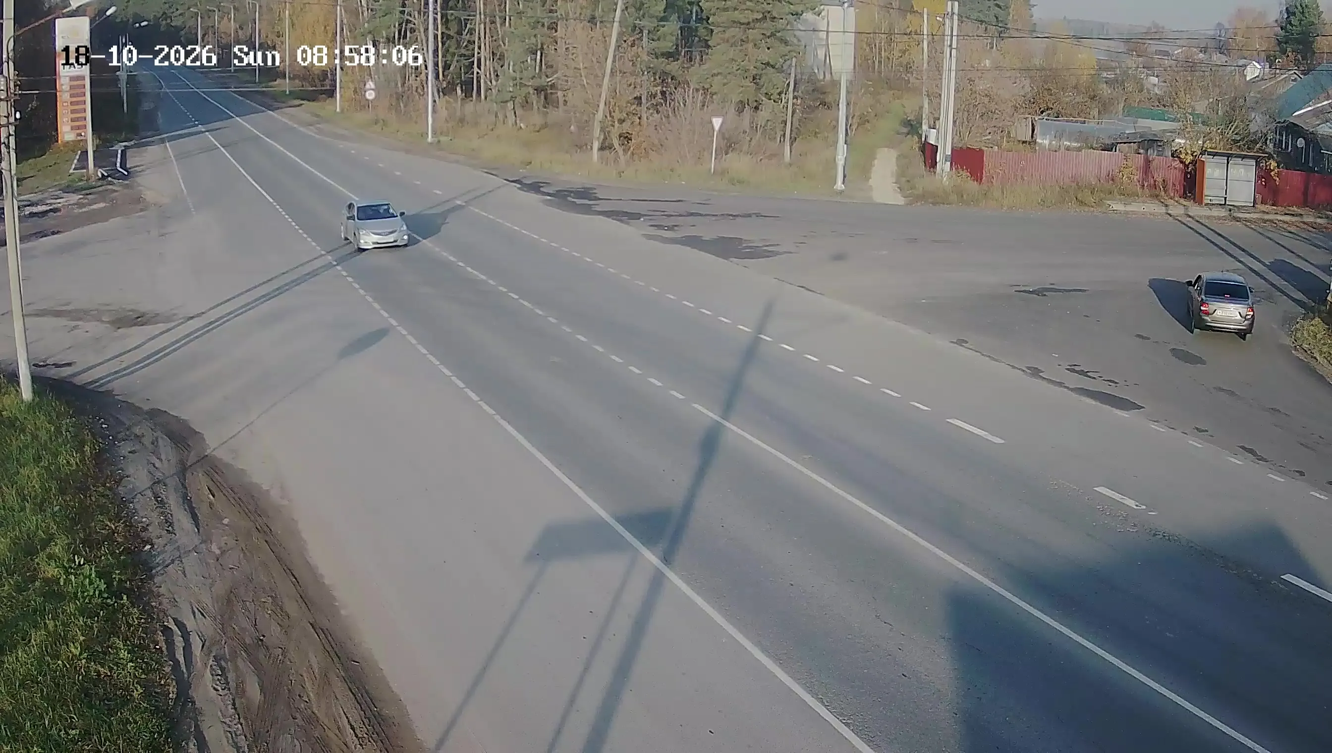
The live webcam at the intersection of the A108 Highway near Manila Village broadcasts in real time the multi-lane federal highway with markings, along which passenger cars and freight vehicles move. In the center of the frame is a traffic light with signals for vehicles and pedestrians, as well as a pedestrian crossing across the highway.
On the left side of the image are commercial buildings, greenhouses, and advertising structures — typical roadside infrastructure of a Moscow Region highway. On the right, a lawn area with road signs is visible: a priority road sign and a pedestrian crossing warning sign. The top of the frame displays a digital panel with the date and time.
The camera at the A108 intersection shows the road situation in real time: traffic intensity, weather conditions — precipitation, snow cover, ice — as well as the condition of the road surface. This is especially valuable for drivers planning a route along the Moscow Big Ring Road, and for local residents of Filipkovskoye and Manila who use this intersection daily.
Similar cameras
Find similar


Author's other cameras
All cameras